When Typhoons Meet Autumn Fronts, Japan's Warning System Falls Short
Typhoon 24 stalling south of Japan is converging with a southward-moving autumn rain front, creating a double-disaster scenario that Japan's current warning framework wasn't built to handle. As climate change intensifies these collisions, experts say Tokyo needs a higher-tier alert for compound weather events.
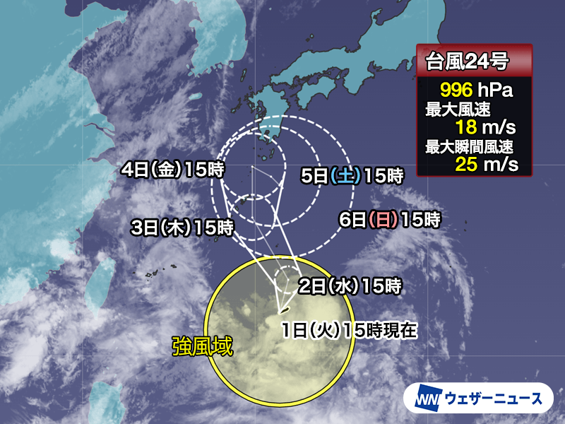
The Collision No One Is Talking About
Typhoon 24, known internationally as Krovanh, has been hovering south of Japan since Sept. 1 with maximum sustained winds of only 18 meters per second — barely a tropical storm by the time it reaches land. By any conventional metric, it is not a threatening system. But Weather News is tracking something more dangerous than wind speed: Krovanh is on a collision course with the autumn rain front, a band of moisture stretching down from the Sea of Japan toward Honshu. When these two systems interact, the result is not a typhoon. It is a rain engine.
This is the scenario that killed hundreds in Western Japan in July 2024. And it is happening again.
How a Weak Typhoon Becomes a Flood Machine
The mechanics are straightforward but deadly. Krovanh is moving slowly northward along the edge of the Pacific high-pressure system. As it does, it acts as a pump, drawing moisture-laden air from the south and driving it directly into the path of the retreating autumn front coming down from the north. The front itself is not intensifying on its own, but the tropical moisture feeding into it causes clouds to deepen and rainfall rates to spike.
Weather News notes that the heaviest activity is expected around Sept. 4, when the front will be most active across a broad swath from western to eastern Japan. The timing and exact path depend entirely on what happens to Krovanh after day four — and that is where the uncertainty explodes. Forecast models diverge sharply at that point: one scenario sees the typhoon caught by a trough and pushed eastward; another has a high-pressure system building behind it, blocking progress and leaving it stalled against the front indefinitely.
If the latter plays out, rain could hammer the same areas for days. That is the difference between a weather event and a disaster.
The Drought Paradox
Western Japan has been dry since July, with some areas recording significantly below-average rainfall. The incoming rain could relieve reservoir shortages — but cracked, parched soil absorbs water poorly, meaning a larger percentage of rainfall becomes runoff rather than infiltration. That runoff feeds into already-stressed river systems and saturates slopes that have been drying out for weeks. The paradox is brutal: a typhoon that looks harmless on a satellite image can trigger landslides and flash floods in ground that has lost its ability to cope.
This is why meteorologists in Japan increasingly refer to these events as compound disasters — where the total risk exceeds the sum of individual threats. The drought makes the soil vulnerable. The typhoon supplies the water. The front locks it in place. Each element alone is manageable. Together, they overwhelm drainage, river capacity, and evacuation timelines.
Japan’s Warning System Was Built for a Single Threat
Japan’s disaster预警 system is one of the most sophisticated in the world, but it is designed around individual hazards. There are warnings for heavy rain, for flooding, for landslides, each triggered when thresholds are crossed. What the system lacks is a formal alert level that accounts for the interaction between a tropical cyclone and a stationary front — the very scenario that produces the longest-duration, highest-impact rainfall events.
After the July 2024 Western Japan floods, which killed more than 200 people and displaced tens of thousands, the Cabinet Office established the Heavy Rain Emergency Disaster Prevention System. It raises the alert level when rain intensity exceeds a “once-in-50-years” threshold, triggering mandatory evacuations. But the system was calibrated for rainfall from a single storm system, not for the compounding effect of a typhoon feeding a frontal zone. When the interaction stretches rainfall over 72 hours instead of 12, the cumulative impact can exceed the model’s design parameters — and that gap is where lives are lost.
The Climate Signal Is Clear
The broader context matters. This year, typhoons have been forming at an unusually early and rapid pace. August alone saw 10 typhoons — the most in a single month since 1966. From January through August, every month has produced at least one typhoon, a pattern that has occurred only three times since records began in 1951: 1965, 2015, and now 2026.
Warmer sea surface temperatures in the western Pacific provide more energy for storm formation and allow systems like Krovanh to survive longer at lower latitudes before making landfall. At the same time, the autumn front is shifting southward earlier and carrying more moisture, as a warmer atmosphere holds more water vapor — roughly 7% more per degree Celsius of warming. The overlap zone between typhoon moisture and frontal systems is expanding both geographically and temporally.
What was once a rare alignment is becoming a recurring hazard pattern.
What Changes If Nothing Else Does
The immediate lesson from Typhoon 24 is practical: residents across western and eastern Japan should monitor the situation closely, especially if Krovanh stalls after Sept. 4. The rainfall forecast is not about peak intensity but duration. Even a category-one system, if it holds position against a saturated front, can dump months of rain in a matter of days.
The deeper lesson is institutional. Japan’s warning system needs an explicit compound-disaster tier — one that activates when a tropical cyclone and a stationary front are converging, regardless of the typhoon’s wind speed. Such a tier would prioritize evacuation orders based on projected rainfall accumulation and soil saturation, not just hourly rain rates. It would also require better coordination between the Japan Meteorological Agency and local municipalities, ensuring that drought-stricken areas receive proportionally higher alerts despite appearing less immediately threatening on radar.
China and Taiwan are already dealing with Typhoon 18, Saudel, moving through the South China Sea with heavy rain expected along the Fujian and Zhejiang coasts and southern Taiwan. The same compound-risk logic applies there as well. When typhoons meet frontal systems, no coastline is immune.
Krovanh may be a weak storm on paper. But paper metrics do not stop landslides. Japan has seen this movie before. The question is whether it will rewrite the ending this time.